
CA, US · Best: May–Oct
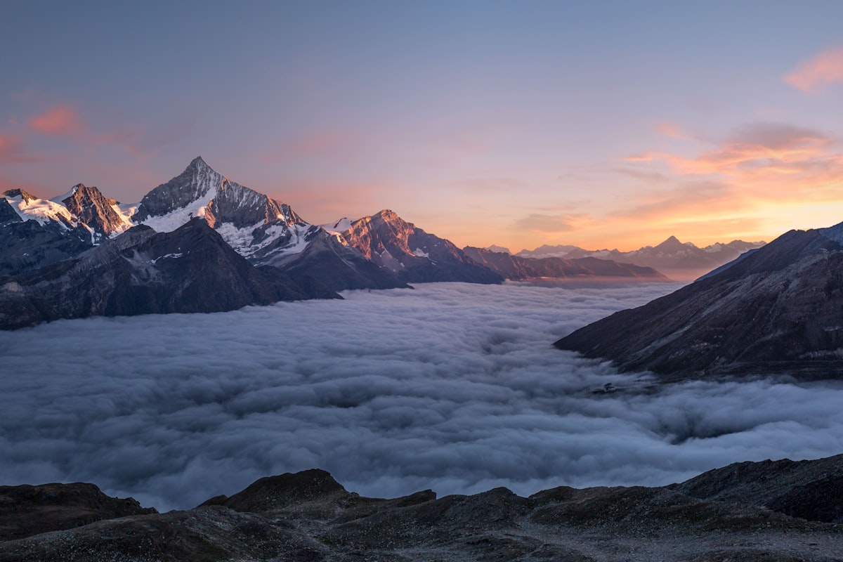
Yosemite National Park
Granite walls, giant sequoias, and some of the most iconic hiking on Earth. Yosemite spans nearly 1,200 square miles in California's Sierra Nevada.
Trails in Yosemite National Park
Itineraries
Plan a Yosemite National Park trip
Affiliate links — we earn a small commission when you book through these, at no cost to you. Disclosure.
Photos


Why Yosemite is worth the planning hassle
El Capitan and Half Dome are the obvious draws, but the park's real distinction is range. In a single trip you can stand under a 2,400-foot waterfall in Yosemite Valley, walk among 2,000-year-old sequoias in Mariposa Grove, and sleep above 8,500 feet in the Tuolumne high country. Few parks compress that much vertical and ecological variety into one boundary. Jake, who has spent more time in the Sierra than anywhere else, tends to push first-timers past the Valley floor as soon as they've seen the headline views — the park gets dramatically quieter a few miles in any direction.
When to go
Each season is a real tradeoff, not a preference.
- Late April–June: Waterfalls run at full volume from snowmelt. Yosemite Falls, Vernal, Bridalveil — all loud. Tioga Road over the high country is usually still closed into late May or June.
- July–August: Tioga and Glacier Point Roads open, the high country is in season, and Half Dome cables are up. Also peak crowds, peak heat in the Valley, and falls that may be down to a trickle by August.
- September–October: The team's general pick. Cooler Valley temps, thinner crowds after Labor Day, Tuolumne still accessible until the first storms close Tioga (often mid-to-late October, sometimes earlier).
- November–March: Valley only for most visitors. Badger Pass skiing, frozen falls, and a very different park. Chains often required.
Key zones
Yosemite Valley
Seven miles long, 4,000 feet deep, and where most of the iconic viewpoints live: Tunnel View, El Capitan Meadow, Mirror Lake, the base of Yosemite Falls. Also where most of the traffic, lodging, and food service is concentrated.
Glacier Point and Wawona
Glacier Point delivers the postcard look down onto Half Dome and the high country without a serious hike — assuming the road is open. Wawona, to the south, anchors Mariposa Grove and the historic hotel district.
Tuolumne Meadows and the high country
Above 8,000 feet, accessed via Tioga Road. Cathedral Lakes, Lembert Dome, the start of the JMT/PCT corridor. This is where Mia and Rae both gravitate when the Valley feels overrun.
Hetch Hetchy
The forgotten northwest corner. A reservoir, a few big waterfalls in spring, and a fraction of the foot traffic.
Trails and activities to anchor on
- Mist Trail to Vernal and Nevada Falls: The defining Valley day hike. Wet, crowded, worth it.
- Half Dome via the cables: Permit-only by lottery, roughly 16 miles round trip, cables typically up late May through mid-October.
- Upper Yosemite Falls: 7.6 miles, ~2,700 feet of gain, best in spring.
- Cathedral Lakes (Tuolumne): A more reasonable introduction to the high country.
- Climbing and bouldering: Camp 4 culture, world-class granite. Beginners should hire a guide service.
- Cycling the Valley loop: Flat, paved, and a faster way to move than driving in summer.
Getting there, permits, crowds
The Valley is roughly four hours from San Francisco, six from Los Angeles, and three from Reno via Tioga Pass when it's open. Fresno (FAT) is the closest commercial airport for southern entry. Yosemite has used a peak-hours reservation system in recent summers — check the official site before you book anything else, because the rules change year to year. Half Dome cables and most overnight wilderness trips require separate permits. For wilderness permits, plan around the early-access lottery window or be ready to compete for walk-up slots.
Where to stay
Inside the park: Yosemite Valley lodging (the Ahwahnee, Yosemite Valley Lodge, Curry Village) books out months ahead for summer. Wawona and the high-country options at Tuolumne Meadows Lodge and the High Sierra Camps are quieter but seasonal. Campgrounds release on a rolling reservation window and disappear within minutes.
Outside the park: El Portal and Fish Camp are closest to the Valley and south entrance. Groveland sits near the Big Oak Flat (Highway 120) entrance. Mariposa and Oakhurst are larger towns with more options about 45 minutes to an hour out. For Tuolumne access from the east, Lee Vining on the shore of Mono Lake is the obvious base.
If Yosemite is full
It happens. Sequoia and Kings Canyon, two to three hours south, deliver bigger trees and a fraction of the visitation. The Eastern Sierra around Mammoth, Bishop, and the June Lake Loop is Jake's home turf and offers comparable granite without the gate lines. For a different kind of trip altogether, Lassen Volcanic to the north is one of the most underused parks in California.
Common questions about Yosemite National Park
- Do I need a reservation just to enter Yosemite?
- Yosemite has used a peak-hours day-use reservation system in recent summers, but the rules shift year to year. Check the official NPS Yosemite page before booking flights or lodging — we've seen the system come and go and change windows from one season to the next.
- When does Tioga Road actually open?
- There's no fixed date — it depends entirely on snowpack and plowing. Late May to early June is typical, but big snow years can push it into July, and it usually closes again sometime in October or November after the first serious storm.
- Is September really less crowded, or is that a myth?
- It's real, but mainly after Labor Day. Valley parking and trail traffic drop noticeably mid-September onward, waterfalls are admittedly thin, and Tuolumne is still open until Tioga closes — it's our default recommendation for first-timers who can't go in spring.
- How hard is the Mist Trail, and do I need to do the whole thing?
- To the top of Vernal Fall is roughly 2.4 miles round trip with about 1,000 feet of gain on wet granite steps — manageable for most fit hikers. Continuing to Nevada Fall roughly doubles both numbers, and a lot of people turn around at Vernal without regrets.
- Can I climb Half Dome without a permit if I'm willing to wait?
- No. Cables-day permits are required every day the cables are up, distributed via a preseason lottery and a smaller daily lottery two days ahead. Rangers do check at the subdome, and going up the cables without one is a fineable offense.
- Is it worth driving out to Hetch Hetchy?
- If you've already seen the Valley headliners and want spring waterfalls without the crowds, yes — Wapama and Tueeulala run hard in May. In late summer it's drier and the payoff drops, so we'd skip it on a short trip in August.
- Where should I stay if everything inside the park is booked?
- El Portal on Highway 140 is the closest gateway and keeps you on a year-round road into the Valley. Groveland (Highway 120) and Oakhurst/Fish Camp (Highway 41) are the other two main options — pick based on which entrance matches your itinerary, since driving between them eats hours.