hiking · hard
Mount Bierstadt (14,065 ft)
- Distance
- 11.30 km
- Elevation
- 850 m
- Duration
- 5.0 h
- Season
- Jul–Sep
Rae here. Bierstadt is the 14er a lot of Front Range hikers cut their teeth on, and for good reason — the trail off Guanella Pass starts you above 11,500 ft, so the 850 m of gain over 11.3 km out-and-back is the easiest math you'll find on a Colorado fourteen-thousand-foot peak. That doesn't mean it's a stroll. The altitude does the work the trail doesn't, and the upper ridge has more to it than the photos suggest.
The trail
From the Guanella Pass trailhead you drop almost immediately into the willows of the Mt. Evans Wilderness — a flat, boardwalked section that crosses Scott Gomer Creek. This used to be the bushwhack-from-hell phase of the route; the boardwalk has tamed it, but expect mud where the planks end and trail begins. Past the willows the path tilts up through tundra, climbs a broad shoulder, and meets the southwest ridge.
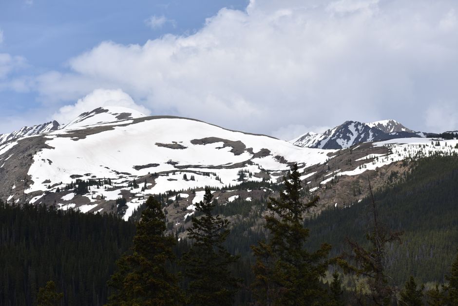
The ridge is where Bierstadt earns the 14er badge. The grade steepens, the trail breaks into talus and dinner-plate rock, and the final 150 vertical meters are a hands-occasionally-out scramble through boulders. Cairns mark the line but route-finding gets fussy in the last block field — pick a path that keeps you on solid rock rather than chasing the fall line. The summit is broad, with a clear look across the Sawtooth ridge to Mt. Blue Sky (formerly Evans).
Round trip in 5 hours is realistic for a fit hiker who's acclimated. Coming up from sea level the day before? Add an hour and don't be embarrassed about it.
When to go
Standard season is mid-June through late September, with July and August the most reliable. Snow lingers in the upper gully into June some years and the willows stay swampy until things dry out. The hard rule: be off the summit by noon, ideally earlier. Afternoon thunderstorms on the Front Range build fast, and the upper ridge is fully exposed with nowhere to hide. Most parties start between 5 and 6 a.m.
September brings cooler temps, fewer storms, and gold tundra, but also early snow events. October is winter conditions for planning purposes — traction and an ice axe become real considerations.
What to know before you go
- Parking: Guanella Pass lot fills by 6 a.m. on summer weekends. Overflow parking is down the road and adds distance both ways. Weekday starts are dramatically saner.
- Permits: No permit or fee for the hike itself. The Guanella Pass road is paved and open to passenger cars in summer; it closes in winter from the Grant side.
- Altitude: The summit is over 14,000 ft and the trailhead isn't far below it. Sleep high the night before if you can — Georgetown, Grant, or a pass-side car camp all help. Headache, nausea, and unusual fatigue mean turn around.
- Water: Scott Gomer Creek near the start is the only reliable source and it requires treatment. Plan to carry everything you'll need — most hikers bring 2 to 3 liters.
- Navigation: The willows and lower trail are obvious. The summit boulder field is where people drift. In poor visibility, the descent off the summit block is the most common place to lose the line.
- Dogs: Allowed, but the upper talus is hard on paws and the exposure is real. Many dogs do fine; some need carrying off the boulder field.
What to bring
Treat this as an alpine day even in July. Layers including a wind shell and an insulating piece, a brimmed hat plus a warm hat, sun protection (the UV at altitude is brutal and the tundra gives you zero shade), gloves for the summit block, sturdy trail runners or light boots with decent rock protection, trekking poles if your knees prefer them, and a real first-aid kit. Headlamp for the pre-dawn start. A paper map or downloaded offline track — phone batteries die fast in the cold.
Variations
- Sawtooth traverse to Mt. Blue Sky: The classic add-on. Connects Bierstadt to Blue Sky via the Sawtooth, an exposed Class 3 ridge with significant route-finding. This is a different beast — full alpine experience, much longer day, and best done with prior scrambling experience or a partner who's run it before.
- Shorter turnaround: The willows and tundra below the ridge make a worthwhile half-day if weather closes in or altitude is hitting hard. Turning around at the base of the ridge still gives you most of the views.
- Sunrise summit: Headlamp start around 3:30 a.m. puts you on top for first light over the Sawtooth. Cold, windy, and worth the early alarm if the forecast cooperates.
Common questions
- How long does it take to hike Mount Bierstadt?
- A fit, acclimated hiker can do the 11.3 km round trip in about 5 hours. If you're coming up from sea level the day before, plan on 6 to 7 hours and pace yourself on the upper ridge.
- Is Mount Bierstadt a good first 14er?
- Yes — it's the most common starter 14er on the Front Range because the Guanella Pass trailhead sits above 11,500 ft, so you only gain about 850 m. The altitude is still the crux, and the final 150 vertical meters involve hands-on scrambling through talus.
- What time should I start hiking Bierstadt?
- Most parties leave the trailhead between 5 and 6 a.m. with the goal of being off the summit by noon. The upper ridge is fully exposed and Front Range thunderstorms build fast in summer afternoons.
- When does the Guanella Pass trailhead parking fill up?
- On summer weekends the lot is typically full by 6 a.m. Overflow parking is farther down the road and adds distance to both ends of your day. Weekdays are noticeably less crowded.
- Do I need a permit to hike Mount Bierstadt?
- No permit or fee is required for the hike. The Guanella Pass road is paved and open to passenger cars in summer, but it closes in winter from the Grant side.
- Can I bring my dog up Bierstadt?
- Dogs are allowed, but we'd think hard about the upper talus — the dinner-plate rock is rough on paws and the scramble has real exposure. Some dogs handle it fine, others need to be carried through the summit boulder field.
- Is the Sawtooth traverse to Mt. Blue Sky doable as a day hike?
- It's doable but it's a different objective — Class 3 scrambling on an exposed ridge with serious route-finding, and a much longer day overall. We'd only recommend it if you've got prior scrambling experience or are going with someone who does.


